

About 1,382 containers are lost at sea every year on average. On land, cargo theft incidents across the U.S. and Canada rose 27% in 2024. The market for GPS tracking for containers now sits at $10.85 billion and is growing at nearly 8% annually, because the cost of not knowing where your box is has become impossible to absorb.
But most buyers of container GPS trackers are still solving the wrong problem. They track the shipment. The container itself, as a reusable capital asset, goes invisible the moment freight is delivered. I’ve watched this pattern repeat across aviation, port operations, and industrial freight for over 15 years. The gap between shipment visibility and full-cycle asset tracking is where operational dollars leak.
This guide covers the full stack: how the technology works, which connectivity option fits your lanes, what “10-year battery life” actually means under real conditions, and the five ROI levers that make or break the business case. The principles here mirror broader GPS tracking for equipment implementations, but containers introduce unique challenges around global transit and reusable asset cycles.
Shipment Tracking vs. Asset Tracking: The Distinction That Costs You Money
Most “container tracking” solutions on the market are shipment trackers in disguise. They follow a container from origin to destination. Once the freight is delivered, the job ends. The tracker goes dormant.
That leaves the entire return, idle, and reuse cycle blind.
For a fleet manager overseeing 500 reusable containers (or a leasing company with boxes scattered across three continents), the difference between shipment tracking and asset tracking is the difference between knowing where containers are during transit and knowing where they are always. The latter catches a 40-foot box sitting empty in a customer yard three weeks past its return window. The former does not.
| Dimension | Shipment Tracking | Asset Tracking |
|---|---|---|
| Visibility window | Origin to destination | Full lifecycle: deploy, transit, deliver, dwell, return, reuse |
| Tracks the… | Cargo or shipment | Container as a capital asset |
| Core ROI | Fewer lost shipments | Higher utilization, faster cycle time, smaller fleet needed |
| Typical buyer | Freight forwarder, shipper | Container owner, lessor, fleet manager |
| Ends when… | Proof of delivery | Asset retirement |
Everything in this article applies to both approaches. But the companies extracting the highest return from GPS container tracking treat containers as assets with full-cycle visibility, not as cargo vessels on one-way trips. If your container pool goes dark after delivery, that is the gap worth closing first.
How Container GPS Tracking Works
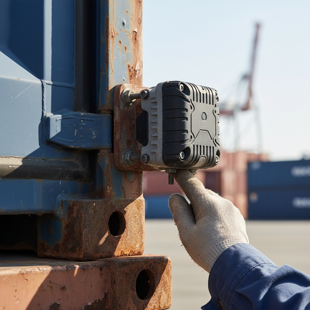
A modern container tracker is not a single device. It is a layered stack: positioning hardware, a sensor cluster, a communication modem, and a cloud platform that makes the data useful. Understanding the layers matters because each one involves trade-offs that affect battery life, cost, and accuracy.
Positioning: GNSS, Not Just GPS
Today’s trackers use multi-constellation GNSS receivers pulling signals from GPS, GLONASS, Galileo, and BeiDou simultaneously. Multi-constellation fixes reduce time-to-first-fix and improve accuracy in port environments where steel stacks and gantry cranes create signal shadows. Outdoor accuracy is typically ±5 meters. Inside a steel container, expect ±15 to 25 meters depending on stacking depth and receiver quality.
Sensors Beyond Location
Location alone rarely solves the full operational problem. Modern trackers bundle additional sensor data that shapes decisions well beyond “where is my box.”
- Door open/close detection (Hall-effect or accelerometer-based) flags tampering and measures dwell time at each stop.
- Temperature and humidity probes handle cold-chain compliance for reefer and pharmaceutical freight.
- Shock and tilt sensors create evidence trails for damage liability and rough-handling claims.
- Light exposure sensors distinguish legitimate door opens from break-in attempts.
For pharmaceutical and perishable shipments, calibrated temperature probes paired with GPS timestamps produce the audit trail that satisfies EU GDP guidelines and PDA Technical Report 39.
Platform: Where Pings Become Decisions
Raw coordinates mean nothing without context. The cloud platform (SaaS dashboards, API feeds into TMS/WMS/ERP, geofence-triggered alerts) turns location data into operational action. REST and MQTT integrations push data into SAP, Oracle TMS, project44, FourKites, and carrier portals like Hapag-Lloyd LIVE or Maersk Track & Trace. That is where “I know where it is” becomes “I know it’s four days late, the customer hasn’t unloaded it, and here’s the detention invoice.”
Cellular, Satellite, or Hybrid: The Connectivity Decision
This is the most consequential technical choice in container GPS tracking. It determines battery life, cost per message, and whether your tracker goes silent mid-ocean.
Cellular (LTE-M, NB-IoT)
Cheapest to operate. Lowest power draw. Works in 95%+ of ports, terminals, and inland scenarios. LTE-M and NB-IoT are the standard for battery-powered asset trackers because they penetrate deep into container stacks and warehouse environments. Monthly data plans run roughly $5 to $15 per device.
The limitation is simple: no cellular coverage at sea. A container on a trans-Pacific voyage goes dark for 10 to 20 days. For domestic trucking, rail, and drayage-only use cases, cellular is sufficient.
Satellite (Iridium, Inmarsat, Kinéis)
Global coverage including mid-ocean. The trade-off is cost: satellite airtime runs 10x to 50x the cost of cellular per message, and hardware sits at $250 to $600 per unit. Battery draw per transmission is also higher.
Satellite-only deployments fit high-value cargo on long ocean legs where a multi-week blackout is unacceptable. Think pharma cold-chain, aerospace components, or defense logistics.
Hybrid (Cellular + Satellite Fallback)
Cellular where available, satellite at sea. Most expensive hardware, but the only architecture that delivers global, uninterrupted visibility from warehouse to warehouse. If your containers cross oceans regularly and the cargo value justifies the airtime, hybrid is the answer.
The 2G/3G Sunset
If your container fleet still runs on 2G or 3G trackers, the replacement deadline is already here. Major carriers worldwide have shut down or announced firm sunset dates for legacy cellular networks. Any tracker deployed in 2026 should run LTE-M, NB-IoT, or LTE Cat-1bis at minimum. Deploying legacy cellular now means forced hardware replacement within two to four years, on top of degrading coverage in the interim.
Battery Life: What “10 Years” Actually Means
Every hardware vendor in this market claims “up to 10 years of battery life.” The number is real. The footnote is the size of a shipping manifest.
“10 years” assumes one location report per day, with the device asleep for roughly 23 hours and 55 minutes per cycle. Under that duty cycle, a lithium primary cell (Li-SOCl₂) can sustain a decade of service. Digital Matter publishes this spec for its Yabby Edge and Oyster3 product lines, with built-in battery management that optimizes wake intervals.
Change the report frequency and the math shifts fast:
| Report Frequency | Approximate Battery Life |
|---|---|
| 1 per day | 7 to 10 years |
| 4 per day | 3 to 5 years |
| Every 30 min (motion-triggered) | 1 to 2 years |
| Every 5 min (live recovery mode) | 6 to 12 months |
Solar-assisted models like the Oyster3 extend life by recharging during daylight hours. That works well when the tracker sees sunlight. Containers stacked three-deep in a port yard don’t cooperate.
The practical question is not how long the battery lasts. It is how often your operation truly needs a position fix. In my experience, four reports per day hits the sweet spot for most container pool operators tracking cycle time and dwell. High-value pharma drayage might need updates every 15 minutes, but that is a different deployment with different economics. Size the duty cycle to the use case, not to the marketing headline.
Five Ways Container GPS Tracking Pays for Itself
Spec sheets sell features. Operations teams buy outcomes. These five ROI levers are where container GPS tracking produces measurable returns, roughly in order of speed to payback.
1. Theft and Loss Reduction
According to CargoNet, cargo theft incidents rose 27% in 2024 across the U.S. and Canada, with electronics, apparel, and pharmaceuticals the most targeted categories. GPS-triggered geofence alerts catch route deviations in minutes. Industry data from CargoNet and Sensitech shows that early-warning alerts reduce average theft losses by 40 to 60% per affected shipment. At scale, this alone can cover the hardware investment inside a single fiscal quarter.
2. Detention and Demurrage Avoidance
Detention charges stack up when a container sits at a customer facility past the free-time window. Without GPS data, you rely on phone calls, driver check-ins, and best guesses. With geofenced tracking, the system flags the moment a box crosses a dwell threshold. Finance can issue retrieval orders instead of discovering a $200-per-day detention charge three weeks after the fact.
3. Cycle Time Compression
If you own or lease reusable containers, fleet size is a direct function of cycle time. A container cycling in 30 days instead of 45 means you need 33% fewer units to cover the same throughput. GPS data exposes where time bleeds: slow unloading, forgotten empties, inefficient return routes. Compress the cycle, shrink the required fleet, defer the capital expenditure on new boxes.
4. Invoice Dispute Resolution
“We returned it on the 15th.” “Our records show the 22nd.” Without location data, it is a stalemate. GPS timestamps with geofence records convert rental disputes into verifiable facts. One fleet operator I worked with recovered six figures annually in previously uncollectable rental fees after deploying trackers with geofenced proof-of-return.
5. Insurance Premium Reduction
Underwriters increasingly price risk differently for GPS-tracked cargo. Real-time visibility, tamper alerts, and route-deviation monitoring lower the risk profile. Discounts of 5 to 15% on high-value lanes are common enough to include in the business case, especially on pharma and electronics corridors.
Carrier Smart Containers vs. Your Own Tracker
Hapag-Lloyd, CMA CGM, and Maersk have all invested heavily in carrier-owned smart container programs. Hapag-Lloyd LIVE provides location, temperature, humidity, and shock data across its reefer fleet, with dry container coverage expanding. CMA CGM equipped 50,000 containers with Traxens trackers. Maersk runs Remote Container Management on roughly 360,000 reefer units. And in early 2026, WiseTech Global and Hapag-Lloyd launched an IoT pilot pushing anomaly detection and predictive visibility further into carrier-direct offerings.
These programs are a legitimate option if you ship cargo on those carriers. Visibility comes with the booking, no hardware to buy.
But three scenarios consistently break the model:
You own or lease the containers. Carrier IoT tracks the carrier’s boxes, not yours. If you run your own container pool (intermodal, construction, rental, ground support), the carrier’s smart-container program does not follow your asset.
You use multiple carriers. Hapag-Lloyd LIVE covers Hapag-Lloyd containers. CMA CGM Traxens covers CMA CGM boxes. A single shipment that touches two carriers and a drayage provider means stitching three separate visibility platforms together. A third-party tracker bolted to the container gives you one consistent data stream, no matter who moves the box.
You need full-cycle visibility. Carrier tracking typically covers port-to-port or terminal-to-terminal. It does not see your container sitting idle in a customer yard. It does not cover the empty return leg. For asset-tracking use cases where the container’s life between shipments matters more than the shipment itself, third-party hardware is the only option that covers the full lifecycle.
How to Choose a Container GPS Tracker
Before you compare spec sheets, answer four questions.
Are you tracking cargo or the container itself? If your concern ends at proof of delivery, a per-trip shipment tracker may be enough. If you need to know where containers are between trips (idle, in storage, at a customer site), you are in asset-tracking territory and need hardware built for multi-year, always-on deployment.
Where does the container go? Domestic trucking and rail only: cellular works. Trans-ocean routes: satellite fallback is required, unless you accept a 10 to 20 day data gap per voyage.
How often do you need updates? This drives battery life and monthly data cost. Once a day covers utilization analytics. Four times a day handles most operational alerting. Sub-hourly reporting is for active security or high-value in-transit monitoring.
How does the data need to integrate? A standalone dashboard works for small fleets. At scale, you need REST API or MQTT feeds into your TMS, WMS, or ERP. Confirm the platform supports your stack before you commit to hardware.
Watch for Hidden Costs
Hardware price attracts all the attention. Over a five-year deployment, it is rarely the biggest line item.
- Connectivity alone can exceed the hardware cost. Cellular plans at $5 to $15/month per device add up to $300 to $900 over five years. Satellite airtime pushes that to $900 to $3,000.
- Platform SaaS fees (dashboards, geofencing, alerting) add $3 to $10/month per device on top of connectivity.
- International roaming surcharges apply when containers cross borders, unless your SIM or eSIM supports multi-network roaming profiles.
- Integration labor for connecting tracking data to your ERP or TMS takes developer time. Budget for it upfront rather than treating it as an afterthought.
All in, total cost of ownership over five years for a cellular container tracker typically lands between $700 and $1,500 per device. Satellite-hybrid units reach $1,200 to $2,500. Run these numbers against the five ROI levers above. Most operations find that avoiding a single theft incident or cutting cycle time by one week pays for the pool deployment.
If you want to compare hardware options for port and maritime environments, our ocean equipment tracking catalog breaks down specs, battery profiles, and connectivity options side by side. And if you need help mapping the right tracker to your specific lanes and use case, that’s a conversation we have every week: info@datanetiot.com.
Frequently Asked Questions
Do shipping containers come with built-in GPS?
Most do not. Of roughly 50 million TEU in global circulation, only a small fraction carry built-in IoT sensors. Hapag-Lloyd, CMA CGM, and Maersk have equipped portions of their fleets, primarily reefer containers, but the vast majority of dry containers require a third-party GPS tracker mounted on the door, chassis, or interior wall.
Will a GPS tracker work inside a steel container?
Yes, but accuracy drops. Multi-constellation GNSS receivers achieve ±5 meters outdoors and roughly ±15 to 25 meters inside steel containers, depending on stacking. Mounting on the exterior door face or pairing with a BLE repeater inside improves accuracy to ±3 to 5 meters.
How much does container GPS tracking cost per month?
Hardware costs $100 to $400 per unit for cellular trackers, $250 to $600 for satellite-hybrid. Monthly service (connectivity plus platform) ranges from $7 to $25 per device on cellular networks, higher with satellite. Five-year total cost of ownership typically falls between $700 and $2,500 per device.
Can GPS tracking work across oceans without cellular?
Cellular-only trackers lose signal at sea. Satellite-capable units (using Iridium, Inmarsat, or Kinéis LEO networks) maintain global coverage including mid-ocean, with airtime billed per message. Hybrid trackers that switch automatically between cellular and satellite provide the most complete coverage.
What is the difference between RFID and GPS for containers?
RFID tags are passive, battery-free, and short-range. They require a reader or gate to scan them, making them suitable for yard inventory and terminal check-in. GPS trackers actively transmit location data over cellular or satellite networks, providing continuous visibility through transit, idle, and return legs. For a detailed comparison of these technologies, see our analysis of GPS vs RFID tracking. Many operations combine both: RFID at the gate, GPS on the road.
How does GPS data help with detention and demurrage disputes?
GPS with geofencing creates timestamped records of when a container arrives at and departs from a facility. This converts “we returned it on the 15th” disputes into verifiable location evidence. It also enables proactive retrieval alerts before daily detention charges start accumulating.






 +1 508 292 2210

2 Responses