

Ninety percent of world trade moves by sea. You already knew that. What’s less obvious: most of what the industry calls “maritime tracking” stops the moment cargo reaches the terminal gate. AIS tells you where the ship is. Carrier portals confirm the container was discharged. But the asset itself (the container, the chassis, the reusable transport packaging) often vanishes into an operational black hole once it clears the quay.
That gap between “delivered” and “accounted for” is where maritime asset tracking starts earning its keep. The vessel tracking system market alone is projected to reach $3.35 billion by 2035, growing at 11.4% CAGR. Yet organizations still treating visibility as a vessel-level problem are leaving containers, cycle time, and compliance dollars on the table.
This is a field guide for operations leaders who need to track more than ships.
Vessel Tracking vs. Asset Tracking: A Distinction That Costs Real Money
Most people hear “maritime tracking” and picture live ship maps. MarineTraffic. VesselFinder. Colored dots crawling across a blue screen. That’s vessel tracking: knowing where a ship sits at any moment, powered by AIS transponders broadcasting position, speed, and heading every few seconds.
Vessel tracking answers one question: “Where is the ship carrying my stuff?”
Maritime asset tracking answers a completely different set:
- Where is the specific container right now (not the ship, the box)?
- What condition is the cargo in? Temperature, humidity, shock, door status?
- How long has this container been sitting idle at the depot?
- Is it on the return leg, or has it fallen into a dwell-time black hole?
This maps to a distinction I keep coming back to: shipment tracking versus asset tracking. Shipment tracking ends at delivery. The job is done, the data stream dies. Asset tracking follows the asset through its full lifecycle: deployment, transit, delivery, dwell, return, reuse. Every cycle.
The difference shows up directly on balance sheets. With 50+ million intermodal containers in global circulation, even a one-percent visibility gap means hundreds of thousands of units sitting untracked at any given time. Multiply that by per-diem charges, repositioning costs, and replacement procurement, and you start seeing why “the ship arrived” is not the same as “the asset is accounted for.”
The Technology Stack Behind Maritime Visibility
Maritime asset tracking is not a single technology. It’s layers. Each one has a specific job and a specific limitation.
AIS does the heavy lifting at the vessel level. Mandated by the IMO under SOLAS for ships above 300 GT, it broadcasts identity, position, and heading via VHF every 2 to 10 seconds. Shore-based stations pick up the signal within 40 to 60 nautical miles. Beyond coastal range, satellite AIS constellations fill the ocean gaps. Spire Maritime now operates the largest dedicated S-AIS fleet after absorbing exactEarth in 2022.
But AIS tracks ships, not cargo. It carries zero condition data. And it can be switched off entirely, a problem that has gone from theoretical to geopolitical (more on that below).
GNSS receivers (GPS, Galileo, GLONASS, BeiDou) supply the position fix that AIS, IoT sensors, and every tracking platform ultimately depend on. When GNSS degrades, the entire stack degrades with it.
IoT sensors add the context AIS was never designed to carry. Temperature. Humidity. Shock. Light exposure. Door open/close events. For reefer containers hauling pharmaceuticals or perishables, condition data is often more valuable than position. Hapag-Lloyd has documented how IoT sensors on its containers transmit real-time location and condition data, enabling intervention before cargo spoils, not after the claim is filed.
Connectivity is where cost meets physics. In port, cellular works. At sea, you need satellite IoT (Iridium, Astrocast, Globalstar) or LEO broadband. The spread between a low-cost cellular SIM and a $15 to $50/month satellite plan is exactly why most container pools run completely blind during the ocean leg.
RFID and BLE cover the last mile inside terminals: yard inventory, gate-in/gate-out, handling events. Cheap and reliable in controlled environments. Useless the moment the container leaves the terminal perimeter.
The emerging layer is where things shift. LEO broadband from Starlink Maritime and OneWeb is compressing the cost gap between terrestrial and satellite backhaul. Edge AI on board vessels compresses data before transmission, sending anomalies rather than raw streams. And non-AIS position sources (synthetic aperture radar, RF geolocation, optical satellite imagery) are being fused with AIS feeds to find vessels that disappear from the grid.
Where Maritime Asset Tracking Creates Measurable ROI
Technology layers are interesting. ROI is what gets the budget approved. Here’s where the investment pays for itself, with receipts.
Start with reefer and cold-chain monitoring. A single temperature excursion on a pharmaceutical container can wipe out cargo worth six figures. IoT sensors that report temperature, humidity, and door events in real time (transmitting via satellite when at sea) let operations teams intervene the moment conditions deviate. The math is simple: one prevented spoilage event covers the hardware cost for years.
Then there’s reusable container pool management, which is the use case most organizations underestimate. If you’re running any pool of reusable assets (shipping containers, RTIs, specialized crates), dwell time is the silent killer. Every day an asset sits untracked at a consignee’s facility is a day it’s not earning revenue. Asset trackers that report through cellular in yards and satellite IoT during ocean transit close the visibility loop. I’ve seen operations cut average cycle time by 15 to 25% simply by making dwell visible.
Sanctions compliance and dark-ship detection have turned AIS from a logistics tool into a strategic intelligence asset. Between January 2023 and mid-2024, shadow-fleet vessels transported an estimated EUR 103 billion of Russian oil, routinely switching off transponders or spoofing positions. Western regulators now consume commercial AIS feeds to enforce oil-price caps. For freight forwarders and commodity traders, multi-source tracking is quickly becoming a compliance requirement.
Smart port operations represent another high-value application. Rotterdam’s digital twin ingests vessel tracking data alongside infrastructure, hydrology, and weather feeds to optimize berth planning and pilotage. Hamburg and Singapore run similar programs. Every digital twin depends on continuous, high-frequency asset data fed by a resilient vessel monitoring system. Without it, the “twin” is just a pretty map.
Fleet performance and fuel optimization round out the picture. Operators layering tracking data with weather routing report bunker savings of 5 to 15% per voyage. With bunker fuel representing 50 to 60% of vessel operating cost, those percentages translate to real money. EU FuelEU Maritime, in force since January 2025, adds a regulatory stick: continuous emissions monitoring now requires exactly the kind of high-frequency tracking data that once felt optional.
The GNSS Problem Nobody Budgeted For
Here’s the reality check the product brochures skip.
Every technology layer described above depends, directly or indirectly, on GNSS for its position fix. And GNSS is under systematic attack.
Over 10,000 vessels experienced GNSS interference in Q2 2025, an eightfold increase over the prior quarter. The hotspots are conflict-adjacent waters: the Baltic, the Black Sea, the eastern Mediterranean, the Persian Gulf. But the interference does not stay neatly contained. Jamming in the Baltic has degraded positioning accuracy for vessels hundreds of miles from the source.
Spoofing is the nastier variant. Instead of blocking the signal, spoofing feeds the receiver a false position. The ship (or the container tracker) “knows” exactly where it is, and the answer is wrong. Detection requires cross-referencing multiple position sources: AIS behavioral patterns, satellite radar imagery, RF geolocation, onboard inertial measurement units.
For operations teams, this means two things. First, single-source tracking carries structural risk that did not exist five years ago. Second, resilient PNT (position, navigation, timing) systems with anti-jamming receivers and inertial backups are no longer a niche procurement item. They are becoming a line item.
If you’re deploying trackers on containers transiting the Baltic or Mediterranean, factor GNSS resilience into hardware selection. A device that confidently reports the wrong position is worse than one that reports no position at all.
Satellite, Cellular, or Hybrid: Picking the Right Backhaul
Connectivity choice determines both your recurring cost and your actual coverage footprint. Here is how the options stack up in the field.
Cellular (LTE, NB-IoT) is cheap and reliable whenever the asset is within tower range: at port, on road or rail drayage, in warehouses. Monthly costs sit well under $5 per device in most regions. The downside needs no explanation: zero coverage at sea. For coastal or short-sea routes where the vessel stays within 20 to 30 nautical miles of shore, cellular can work. For transoceanic legs, it goes silent.
Satellite IoT (Iridium, Globalstar, Astrocast) provides global coverage, including open ocean and polar routes. Costs range from $10 to $50 per device per month depending on reporting frequency and provider. Battery life matters here: satellite transmissions draw more power, which is a real constraint on battery-powered trackers mounted on unpowered containers. The operational sweet spot is low-frequency reporting (every few hours) during ocean transit, with cellular taking over once the asset reaches port.
Hybrid devices do exactly that: they switch automatically between cellular and satellite based on signal availability. For container pools moving between port and ocean, this is the approach that makes the most financial sense. You pay satellite airtime only during the transit leg.
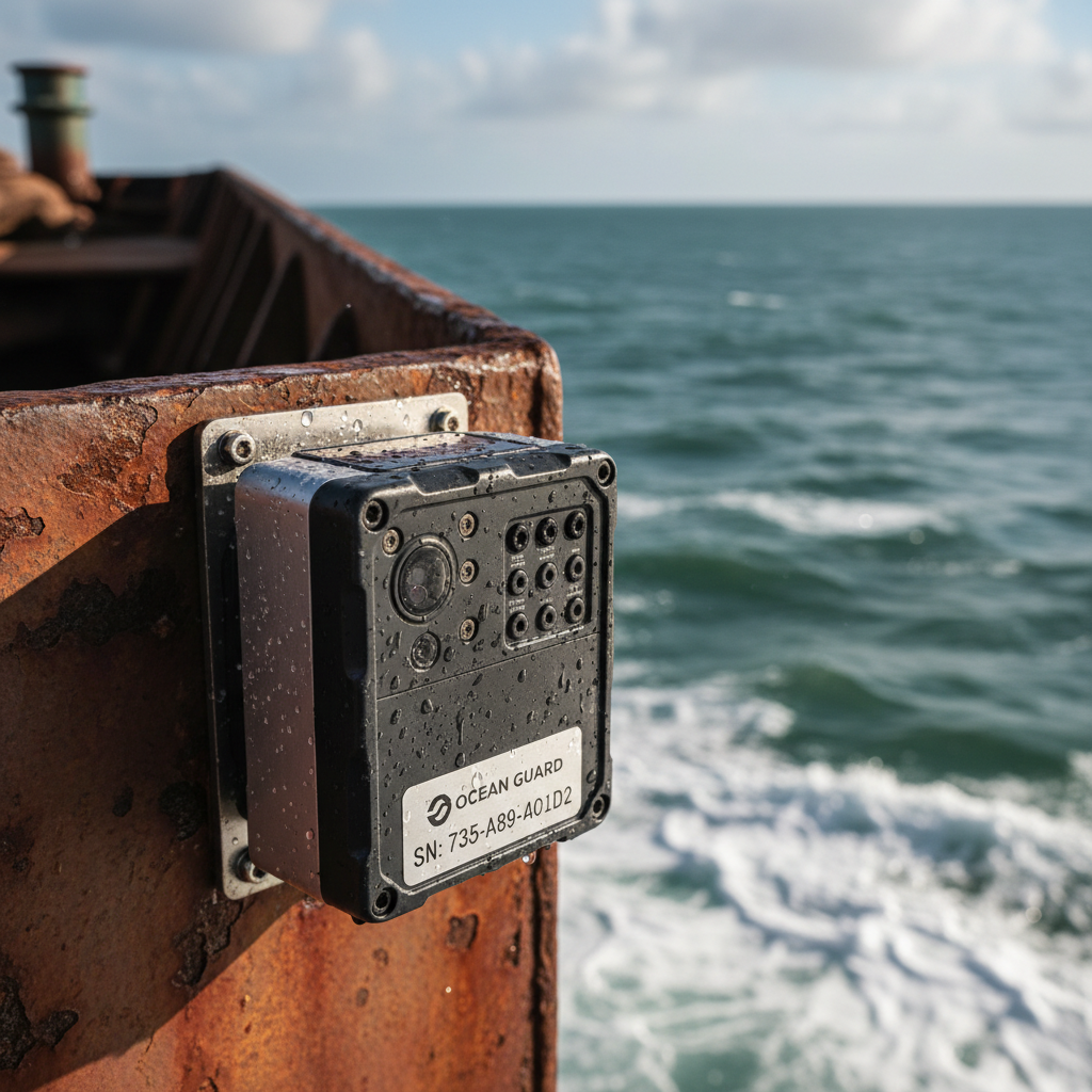
The unpowered asset challenge deserves its own mention. Most intermodal containers have no onboard power. The tracker needs to survive on battery for months or years, handle salt spray, vibration, and temperature swings, and still report frequently enough to be operationally useful. IP67-rated housing and multi-year battery life are minimum specs. Anything below that and you will spend more on field maintenance than you save on visibility.
What the Industry’s Biggest Moves Tell You
Three years of market signals paint a clear picture of where maritime asset tracking is heading.
Kpler’s 2023 acquisition of MarineTraffic and FleetMon consolidated the two largest open AIS data platforms under one company. The signal: raw vessel tracking data is commoditizing fast. The value is migrating upstream into analytics, commodity-flow intelligence, and compliance scoring. If you’re still paying premium prices for basic AIS feeds, you’re paying for a commodity.
TradeLens taught the industry a lesson in governance. IBM and Maersk shut down their blockchain shipping platform in November 2022 despite onboarding over 300 organizations. The technology worked. The problem was that competing carriers refused to feed operational data into a platform controlled by a rival. In maritime tracking, data-sharing incentives and governance structures matter more than the underlying tech.
Carriers, meanwhile, are doubling down. Maersk started rolling out a new onboard connectivity platform across 450 vessels in 2025, embedding edge compute for smarter cargo tracking and remote operations. Hapag-Lloyd continues expanding IoT sensors across its container fleet. The top carriers now treat tracking as a customer-facing product, not a back-office cost center.
Regulation is reinforcing every one of these trends. The IMO adopted the MASS Code in May 2026, establishing the first global framework for autonomous and remote-controlled vessels. Every autonomous ship requires continuous, resilient, multi-source tracking by definition. EU FuelEU Maritime and the IMO’s Carbon Intensity Indicator require auditable data trails built on tracking infrastructure. The regulatory floor under this market is rising steadily.
Three Outcomes That Justify the Investment
When I talk to operations leaders about deploying maritime asset trackers, the conversation almost always comes back to three measurable results:
- Cycle time drops 15 to 25%. Making dwell time visible at consignee sites and depots is the single highest-ROI application for reusable container pools. When the assets are visible, utilization rises and replacement procurement falls.
- Shrinkage and loss stay below 1%. For high-value or theft-prone cargo, geofenced alerts on unauthorized movement pay for themselves within the first incident avoided. One prevented loss can cover a fleet-wide tracker deployment.
- Regulatory compliance becomes a capability, not a scramble. With FuelEU Maritime, the EU ETS extension to shipping, and IMO CII all requiring verifiable data, tracking infrastructure is shifting from operational tool to compliance prerequisite. Building it now costs less than retrofitting under deadline pressure.
If your container pool goes invisible after delivery, or your data stream dies when the ship docks, that is exactly the gap continuous asset tracking closes. Our team designs container visibility solutions that cover the full asset lifecycle, including offshore asset tracking from port to open ocean and back. Reach out at datanetiot.com/contact-us or email info@datanetiot.com.

Frequently Asked Questions
What is maritime asset tracking?
Maritime asset tracking is the continuous monitoring of vessels, containers, cargo, and maritime equipment using AIS, GNSS, IoT sensors, satellite communications, and RFID. Unlike vessel tracking alone, it follows individual assets through their full operational lifecycle, including dwell periods, return legs, and reuse cycles.
How does maritime asset tracking differ from shipment tracking?
Shipment tracking ends at delivery confirmation. Asset tracking continues past that point, monitoring where the container or equipment sits, how long it dwells, and when it returns to circulation. For reusable container pools, this distinction directly affects utilization rates and capital efficiency.
Can containers be tracked during ocean transit without onboard power?
Yes. Battery-powered IoT trackers with satellite backhaul (Iridium, Globalstar, Astrocast) report location and condition data from unpowered containers at sea. Devices rated IP67 or higher with multi-year battery life are built for this use case. Hybrid cellular/satellite devices keep costs manageable by switching to satellite only when out of cellular range.
What is AIS spoofing and why does it matter?
AIS spoofing is the deliberate transmission of false position data to disguise a vessel’s true location. It has surged in conflict-adjacent waters, with over 10,000 vessels affected by GNSS interference in Q2 2025 alone. Mitigation requires cross-referencing AIS against satellite imagery, RF geolocation, and inertial backup systems.
How big is the maritime tracking market?
The vessel tracking system market was valued at $1.14 billion in 2025 and is projected to reach $3.35 billion by 2035. The container tracking market hit $10.85 billion in 2025, forecast to grow to $15.73 billion by 2030. Including smart containers and satellite IoT hardware, the broader maritime visibility market is substantially larger.
What connectivity option works best for ocean container tracking?
Hybrid devices that switch automatically between cellular (in port and on land) and satellite IoT (at sea) offer the best cost-to-coverage ratio. You only pay satellite airtime during the ocean leg. For transoceanic routes, this is the most practical and financially sustainable approach for large container pools.








 +1 508 292 2210

5 Responses