

The vessel monitoring system market is on track to hit USD 2.27 billion by 2034, up from USD 868 million in 2025. An 11.3% CAGR for a technology most fleet operators still treat as a regulatory checkbox they’d rather not pay for.
If you run a fishing fleet, manage port logistics, or sit anywhere in the maritime supply chain, you’ve either installed VMS hardware because a regulator told you to, or you’re about to. Either way, the system sitting on your vessel does more than ping a satellite with GPS coordinates. Or at least it should.
What a Vessel Monitoring System Actually Does
A vessel monitoring system is a satellite-based tracking platform that transmits a vessel’s GPS position, speed, course, and timestamp to a shore-based monitoring center at set intervals. The primary purpose: let fisheries authorities and coast guards know where a vessel is, where it has been, and what it is doing.
NOAA’s Office of Law Enforcement continuously monitors more than 4,000 commercial fishing vessels through VMS in U.S. waters, operating 24/7/365. The Pacific Islands’ Forum Fisheries Agency tracks over 2,000 vessels across 16 Exclusive Economic Zones. The EU Fleet Register ties VMS requirements to roughly 80,000 fishing vessels.
The core job is straightforward: prove that a vessel was (or was not) in a specific area at a specific time. That single data point is the backbone of fisheries compliance, marine protected area enforcement, and catch documentation worldwide. This same principle of location accountability extends beyond fishing vessels to high-value cargo monitoring, where proving chain of custody depends on continuous position verification.
But “straightforward” does not mean “limited.” Once you have reliable, tamper-resistant position data flowing from every vessel in a fleet, the use cases multiply: fuel consumption analysis, route optimization, emissions reporting, insurance validation, charter-party compliance. The regulatory requirement creates the data infrastructure. What you build on top of that infrastructure determines whether VMS is a cost center or an operational advantage.
VMS vs. AIS vs. LRIT: Three Systems, Different Jobs
These three acronyms get conflated constantly. They shouldn’t be. Each was built for a different problem, operates on different technology, and serves different masters.
| Dimension | VMS | AIS | LRIT |
|---|---|---|---|
| Primary purpose | Fisheries compliance and monitoring | Collision avoidance and vessel identification | Long-range security and coastal-state awareness |
| Range | Global (satellite) | VHF line-of-sight (~40 nm), plus satellite AIS | Global (satellite) |
| Transmission | Scheduled (typically hourly) | Continuous autonomous broadcast | Every 6 hours, up to every 15 min on demand |
| Data access | Closed: only the regulating authority | Open: any receiver picks up the signal | Restricted: flag, port, coastal state |
| Applicability | Selected fishing vessels by jurisdiction | SOLAS vessels ≥ 300 GT, all passenger ships | SOLAS cargo ≥ 300 GT and passenger ships |
| Protocol | Proprietary, varies by provider | ITU standard, non-proprietary | IMO/SOLAS regulated |
The USCG published a detailed comparison confirming that AIS and VMS differ fundamentally in design, function, and purpose. Add the LRIT framework the IMO established for long-range security tracking, and the distinctions sharpen further.
The most important difference: AIS is a broadcast system. Everyone within VHF range (or with satellite AIS access) sees your signal. VMS is a closed circuit between the vessel and its regulatory authority. LRIT sits in between, with tiered access controlled by the IMO.
For fishing vessels, this matters politically. AIS tells the world where you are. VMS tells only your regulator. Environmental groups push for open VMS data (Global Fishing Watch has published VMS from several cooperating countries), while vessel operators and some flag states resist, citing commercial sensitivity and security.
They are not interchangeable. A vessel carrying AIS does not satisfy VMS requirements, and a vessel with VMS does not get to skip AIS if SOLAS mandates it. Many jurisdictions now require both.
Where VMS Is Mandatory (and What’s Coming Next)
VMS mandates are expanding, not contracting. Here is the current landscape and what’s on the horizon.
United States
NOAA requires VMS for vessels holding specific federal fishing permits. The list varies by fishery and region: Atlantic herring, North Pacific groundfish, highly migratory species, Gulf reef fish, and others. Transmission intervals default to one hour but drop to every 15 minutes near marine sanctuaries and environmentally sensitive areas. Non-compliance means permit suspension.
European Union
EU fisheries control regulation has required VMS for vessels 12 meters and above since the early 2000s. The amended Control Regulation 2023/2842, which entered into force on 9 January 2024, changes the game significantly:
- Remote Electronic Monitoring (REM), including CCTV cameras and onboard sensors, is now mandatory for high-risk fishing vessels over 18 meters.
- By January 2028, all vessels under 12 meters must be tracked.
- By 2030, some vessels under 9 meters will also be covered, subject to member-state implementation.
That last point deserves attention. Historically, small-scale fisheries have been exempt. That exemption is ending.
Regional Fisheries Management Organizations
RFMOs like NAFO (Northwest Atlantic), WCPFC (Western and Central Pacific), IOTC (Indian Ocean), and ICCAT (Atlantic Tuna) each maintain their own VMS requirements for vessels fishing regulated species in their convention areas. NAFO, for example, requires hourly position reports including geographic position, speed, course, and daily catch.
Pacific Islands
The FFA operates one of the oldest regional VMS platforms, launched in late 1997 and now covering 16 South Pacific member EEZs. It is integrated into the broader TUFMAN system linking VMS with electronic reporting and catch documentation.
The trajectory
More vessels. More data fields. More frequent transmissions. The EU pushing mandatory tracking below 12 meters signals that no commercial fishing vessel will escape electronic monitoring within the next five years in European waters. Other jurisdictions tend to follow that lead, sometimes with a lag of three to five years.
How a VMS Terminal Works
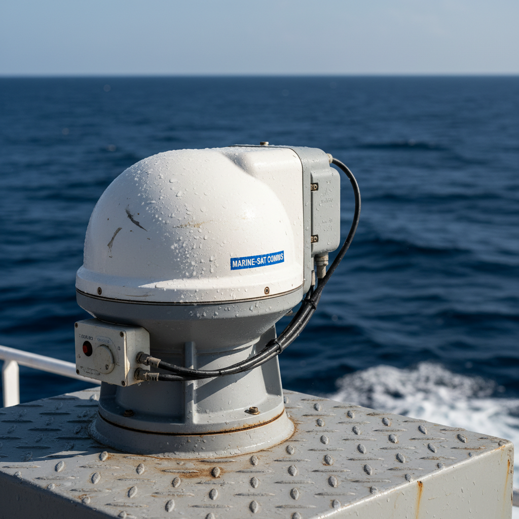
A vessel monitoring system has five functional blocks, whether you’re looking at a compact unit on a 15-meter trawler or a rack-mounted system on a factory ship.
- Onboard terminal. A hardened transceiver (sometimes called a “blue box”) that integrates a GNSS receiver, satellite modem, processor, and backup battery. These are built to withstand salt spray, vibration, and temperature extremes. Common examples include CLS’s NEMO, MetOcean’s iTrac, and the BlueTraker VMS unit.
- Position fix. The GNSS receiver (GPS, GLONASS, Galileo, or BeiDou) captures latitude, longitude, and timestamp, typically to 10 to 15 meters of horizontal accuracy.
- Satellite backhaul. The position packet rides one of several networks:
- Iridium: 66 cross-linked LEO satellites with true pole-to-pole coverage. The dominant choice for fisheries VMS worldwide.
- Inmarsat (now Viasat): geostationary satellites at 35,786 km. More common in merchant shipping and LRIT.
- Argos: French/US LEO system, historically used for early VMS terminals, now largely supplemented by Iridium.
- Cellular (GPRS/4G): used near shore to cut satellite airtime costs. Hybrid terminals switch between cellular and satellite automatically.
- Ground stations and data centers. Receive the satellite uplink and route the data to the relevant Fisheries Monitoring Center (FMC) or commercial platform.
- End-user interface. Web dashboards, GIS overlays, and APIs where regulators or fleet managers view positions, replay tracks, set geofence alerts, and generate compliance reports.
Each position report typically includes: vessel ID (MMSI or IMO number), latitude and longitude, UTC timestamp, course over ground, speed over ground, and heading. Where REM is fitted, the data stream expands to include catch reporting, gear-sensor readings, and camera imagery—a monitoring approach similar to shipment condition monitoring systems that track temperature, humidity, shock, and environmental parameters alongside position data.
Reporting cadence varies by mandate. NOAA defaults to hourly. NAFO requires hourly. LRIT transmits at least every six hours. Some systems support on-demand polling, where the authority requests an immediate position from a specific vessel.
The “Going Dark” Problem
VMS and AIS both depend on a fundamental assumption: the vessel keeps the transmitter on. Many don’t.
An estimated 1,400 tankers now form Russia’s shadow fleet, roughly 11% of the global tanker fleet. These vessels routinely disable AIS to transport sanctioned oil. Over 16,000 AIS gaps were recorded in the Black Sea in the first eight months of 2025, six times the baseline level.
The fishing world has its own version. IUU (illegal, unreported, unregulated) fishing operators disable VMS, spoof positions, or operate under flags of convenience with lax enforcement. A vessel that goes dark near a marine protected area is almost certainly not resting.
Modern VMS terminals are built to resist tampering: sealed enclosures, anti-tamper alarms, cryptographic message authentication, dead-reckoning fallbacks when GPS is jammed. The same challenge shapes approaches to tracking offshore equipment when satellite positioning drops out. But “resistance” is not “prevention.” The technology to detect darkness is improving. Global Fishing Watch combines VMS, AIS, and satellite radar imagery to flag suspicious activity, and their classifiers reportedly exceed 90% accuracy in pilot regions. The U.S. Treasury and EU sanctions bodies now cite AIS manipulation as a formal designation criterion for sanctioned vessels.
In 2026, “going dark” carries consequences it did not five years ago. But for every vessel caught by analytics, others slip through gaps in coverage and political will.
Beyond Compliance: VMS Data as a Business Asset
This is where the conversation needs to shift.
Most operators see VMS as pure cost. Hardware: a few thousand dollars. Satellite airtime: a recurring line item. Installation and maintenance: more time and money. All mandated, none of it (apparently) generating revenue.
The data VMS produces tells a different story.
Emissions and carbon intensity
The IMO’s Data Collection System, mandatory for ships of 5,000 GT and above since 2019, requires reporting of fuel consumption, distance traveled, and hours underway. This feeds the Carbon Intensity Indicator (CII) rating, which grades vessels from A (major superior) to E (inferior). A vessel rated D for three consecutive years, or E for one, must submit a corrective action plan.
The IMO’s Net-Zero Framework, adopted at MEPC ES.2 in October 2025 and entering into force in 2027, raises the bar further. Vessels will need to track well-to-wake emissions intensity. The monitoring infrastructure for that is an extension of VMS: position data combined with fuel and operational data, transmitted via satellite.
Fleet efficiency and commercial intelligence
Commercial fleet managers and commodity traders already use VMS-adjacent data for route optimization, port congestion forecasting, and charter-party compliance. Kpler (which acquired MarineTraffic and FleetMon in 2023) fuses AIS, VMS, and satellite radar into unified dashboards. The data regulators collect for compliance is the same data traders pay to access for market intelligence.
The asset tracking parallel
Here’s a pattern I see repeatedly across industries. A tracking system gets installed for one reason (compliance, security, loss prevention) and then the data stream starts answering operational questions nobody was asking: Where do assets sit idle? Which routes waste fuel? Where do containers disappear for weeks between port and final destination? Answering that last question is exactly what container visibility solutions are built for.
VMS data, combined with catch logs and environmental sensors, can map not just where a vessel went but whether the trip was economically justified. For fleet owners managing dozens of vessels across multiple fisheries, that visibility turns compliance data into planning data, the same logic behind marine equipment tracking at sea. The same principle applies to any asset that moves through a cycle: fishing vessels, shipping containers, ULDs, ground support equipment. The mandate creates the data infrastructure. The ROI comes from what you layer on top of it.
What’s Changing in 2026
Four developments are reshaping the vessel monitoring landscape right now.
Remote Electronic Monitoring goes mandatory. The EU’s amended control regulation is the first major jurisdiction to require cameras and sensors on fishing vessels, not just position tracking. This converts VMS from a location system into a full activity-monitoring platform. Other regions are watching closely.
AI closes the dark-vessel gap. Classification algorithms that fuse satellite AIS, synthetic aperture radar imagery, and VMS data now identify vessels that have gone dark or are spoofing positions. This is moving from pilot programs to operational deployment across multiple RFMO jurisdictions.
Hybrid connectivity cuts the biggest cost complaint. Terminals that switch between cellular (near shore) and satellite (at sea) reduce the single most cited pain for small operators: airtime fees. As Iridium’s Certus broadband matures and coastal cellular coverage extends further, cost-per-report drops meaningfully.
The IMO net-zero framework creates new demand. GHG fuel-intensity limits backed by mandatory DCS data mean every large vessel needs robust monitoring and reporting infrastructure. Providers who serve the fisheries VMS market are expanding into commercial shipping emissions compliance, and the reverse.
The broader vessel tracking market reflects this convergence. The industry is projected to grow from USD 6.07 billion in 2025 to USD 10.64 billion by 2035, driven not just by fisheries compliance but by sanctions enforcement, emissions monitoring, and commercial fleet intelligence.
From Vessel Monitoring to Full Asset Visibility
If you’re installing VMS hardware because a regulator mandates it, you’re already spending the money. The question is whether you extract value beyond avoiding a fine.
A few things worth doing differently:
- Pick a terminal with hybrid connectivity. Satellite-only units cost more per report and limit how often you can practically transmit. Hybrid terminals (cellular near shore, satellite at sea) cut airtime costs and support richer data streams when bandwidth is cheap.
- Integrate VMS data with your operational systems. Position data in isolation is compliance. Position data combined with fuel logs, catch records, maintenance schedules, and weather routing is a decision-support tool. If your VMS platform offers API access, use it.
- Think beyond the vessel itself. The same satellite networks and tracking principles powering VMS can track containers, port equipment, reusable transport assets, and environmental conditions across your maritime supply chain. If you know where the boat is but your cargo disappears the moment it leaves the dock, you have half the picture.
That last point is something we deal with every day at Datanet. The line between vessel monitoring and ocean asset tracking is thinner than most people assume. Different hardware, same underlying need: know where your assets are, what condition they’re in, and when they’re sitting idle instead of generating revenue. If your visibility ends when the vessel docks, there’s a gap worth closing.
We build satellite-based tracking solutions for ocean containers and port logistics using the same GNSS and cellular/satellite infrastructure that underpins VMS. If your operation could use that kind of end-to-end asset visibility, reach out or email info@datanetiot.com. We’re happy to talk through what fits.

Frequently Asked Questions
What is a vessel monitoring system?
A vessel monitoring system (VMS) is a satellite-based platform that transmits a vessel’s GPS position, speed, course, and timestamp to a shore-based monitoring center at regular intervals. It is used primarily by fisheries authorities to track commercial fishing vessels and enforce compliance with fishing regulations and marine protected areas.
What is the difference between VMS, AIS, and LRIT?
VMS is a closed, proprietary system for fisheries compliance, sending position data only to the regulating authority. AIS is an open broadcast system for collision avoidance, visible to anyone with a receiver. LRIT is an IMO-mandated system for long-range vessel identification with tiered access for flag, port, and coastal states. They serve different purposes and are not interchangeable.
Is VMS mandatory for all fishing vessels?
Not universally. Requirements vary by jurisdiction. In the U.S., VMS is required for vessels holding certain federal fishing permits. In the EU, it applies to vessels 12 meters and above, with the 2024 regulation extending tracking to smaller vessels by 2028. Regional fisheries organizations set their own requirements for vessels in their convention areas.
How often does a VMS terminal transmit?
Typically once per hour, though this varies by mandate. NOAA defaults to hourly and increases to every 15 minutes near environmentally sensitive areas. LRIT transmits at least every six hours. Some systems support on-demand polling where authorities request an immediate position from any specific vessel.
Can VMS be disabled or spoofed?
Yes. Despite tamper-resistant features like sealed enclosures and cryptographic authentication, operators can and do disable VMS and AIS transmitters. Over 16,000 AIS gaps were recorded in the Black Sea in the first eight months of 2025, largely linked to sanctions-evading shadow fleets. Countermeasures include satellite radar fusion, AI-driven anomaly detection, and tightening legal consequences.
How much does a VMS terminal cost?
Hardware typically ranges from USD 1,500 to USD 5,000 depending on the terminal, features, and certification requirements. The larger ongoing expense is satellite airtime, which varies by provider, transmission frequency, and connectivity type. Hybrid terminals that switch between cellular and satellite significantly reduce costs for vessels operating near shore.








 +1 508 292 2210

8 Responses